


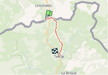
Espace VTT FFC Haute Roya - N° 21 - La Route du Sel

tracegps
User


1h00
Difficulty : Very difficult

FREE GPS app for hiking
 SityTrail
IGN / Geographical institutes
SityTrail Plus
The world is yours!
About
Trail Mountain bike of 10.7 km to be discovered at Piemont, Cuneo, Limone Piemonte. This trail is proposed by tracegps.
Description
Espace VTT - FFC Haute Roya Circuit labellisé par la Fédération Française de Cyclisme. Départ du col de Tende pour arriver à Tende avec possibilité de poursuivre jusqu'à Vintimille. La descente sur le village de Tende est d'une pure beauté, très engagée et très physique. Vous alternerez passages en épingle caillouteux, du sous bois très rapide, devenant de plus en plus technique sur la fin.
Photos

Positioning
Comments